


Auckland Council’s Proposed Plan Change 120 changes the zoning in many Auckland suburbs to allow a massive increase in housing numbers.
Auckland Council has recently released Proposed Plan Change 120 – which changes the zoning of many properties across Auckland to allow a massive increase in potential housing – up to 2 million additional homes (Auckland currently has over 600,000 homes).
But the 2016 Unitary Plan was supposed to last 30 years wasn’t it?
Yes – and it provided zoning changes that would allow over 400,000 additional homes to be built in the city during the 30 years from 2016.
But since then the bipartisan National Policy Statement on Urban Development was passed – requiring councils in larger urban areas to change their plans to allow enormous amounts of development capacity.
They hope that by doing so, there will no longer be a premium on high-density zoned land (because there will be so much of it).
The theory is that developers will be able to buy high-density zoned properties relatively cheaply – which will make it cheaper for developers to build higher density housing, which will lower costs to house buyers.
Wasn’t there another plan change recently?
Yes – Proposed Plan Change 78 was designed to give effect to the National Policy Statement on Urban Development.
However, while it was in process, the 2023 floods caused havoc in many parts of the city. Auckland Council realised that the Unitary Plan would have to be changed again so that areas that had been badly affected by the floods could be given a more appropriate zoning that took into account natural hazards.
Consequently, only parts of Proposed Plan Change 78 were completed – much of it was abandoned pending the creation of a new plan change – created in response to amendments to the National Policy Statement on Urban Development and central government’s direction under the Resource Management Amendment Act 2025.
Proposed Plan Change 120 is the result – it produces the same housing capacity as Plan Change 78, but does so in different ways.
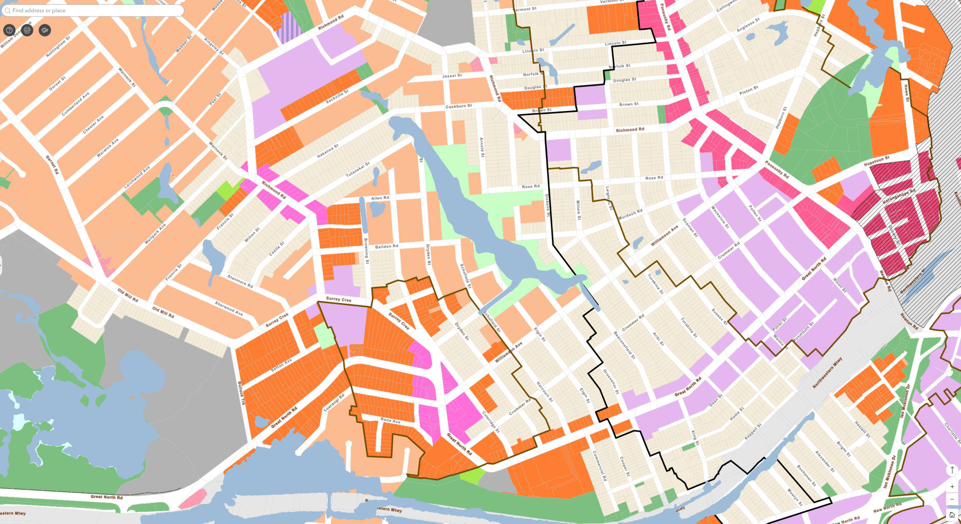
What are the changes in Grey Lynn and Arch Hill?
Auckland Council has decided to keep the Historic Heritage (purple cross hatching) and Special Character zoning (with the exception of a few houses at the bottom of Dryden Street).
Special Character zoned areas retain the single house zoning they had in the 2016 Unitary Plan and are shown on the map below in a blue outline with blue dots.
There is, however, a large amount of upzoning (greater density) in other parts of Grey Lynn.
Pretty much anything that is not Special Character is now either Mixed Housing Urban (allowing multi-unit 3-storey development – shown in light orange) or Terrace House and Apartment Buildings (allowing 6-storey development – shown in dark orange).
If the plan change goes ahead in its current form, 6-storey apartment buildings could be built on a substantial area in the vicinity of the Grey Lynn shops, and also around a proposed bus interchange in Great North Road near the Bullock Track.
Council considers these areas to be walkable catchments where residents wouldn’t need cars.
The Grey Lynn shops are classed as a large local centre. Under the plan large local centres get a 200 metre walkable catchment (brown outline in the map below) but small local centres don’t.
Grey Lynn is the smallest local centre to have been classified large – it’s been put into the same category as much larger shopping centres including Eden Valley (Dominion Road/Valley Road).
Apartment blocks are also proposed for an area at the top of Baildon Road and including Edwards Street and the adjoining part of Allen Road (dark orange).
Along Great North Road and in the streets closest to Ponsonby and Newton Roads, height limits are increased to 50 metres (15 stories) within the City Centre walkable catchment (black outline).
This could lead to significant shading issues for Arch Hill residents.
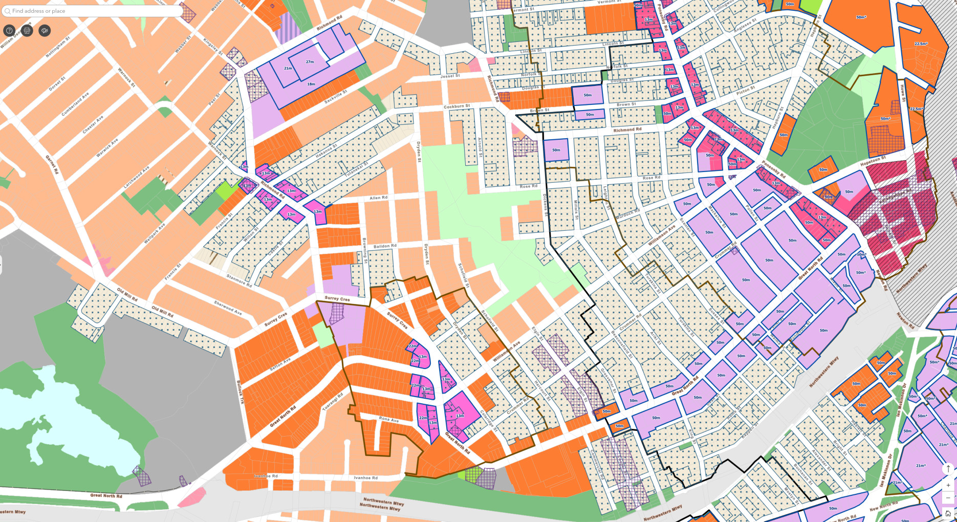
👆Click map to open a large map (1MB) in a new tab.
Shading issues for Arch Hill residents
With Plan Change 120 allowing for a more than doubling of height limits for apartment buildings on Great North Road (currently 6 storeys; increasing to 15 storeys), the impact on Arch Hill in the afternoon is significant.
There will also a large impact on the northern slopes of Grey Lynn below Great North Road in the mornings.
We commissioned the following shading diagrams as part of our work on the Community-led Vision for Great North Road when 6-storey buildings were proposed on Great North Road.
We advocated for a lower height limit on the southern side of Great North Road to protect Arch Hill residents’ daylight.
The second shading diagram shows a large part of Arch Hill in shadow at 2:00 PM and ALL of Arch Hill in complete shadow at 5:00 PM.
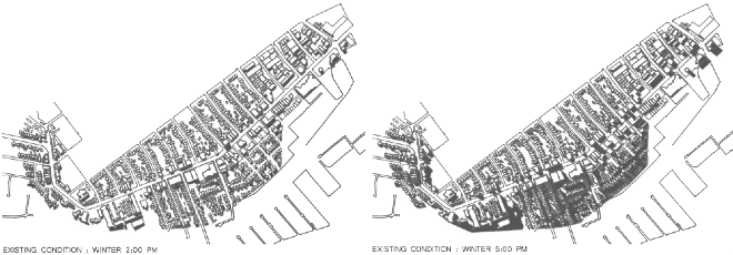
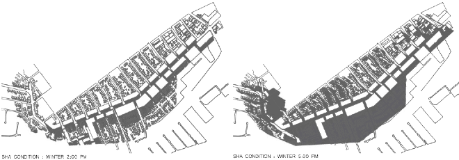
Imagine how little light Arch Hill residents will get in winter if the height limits on Great North Road are doubled.
It’s quite possible ALL of Arch Hill will be in complete shadow from midday in winter.
Wow, why so much high density – surely it won’t all be built?
We know it won’t all get built, and Auckland Council knows this too.
In the view of the GLRA, one of the problems with having such large areas of our city rezoned for high density housing is that most of it will remain low density, with a few tall buildings poking up here and there.
Six- and 15-storey apartments will tower over adjoining one- or two-storey homes, robbing them of privacy and sun. This is a recipe for poor outcomes for neighbourhoods.
We think it would be better for smaller areas to be rezoned for high density housing so that it’s possible to produce well considered centre plans and develop amenities such as neighbourhood parks, restaurant and retail districts and community facilities that make new high-density neighbourhoods really attractive to live in.
We look to overseas examples such as the very dense West End of Vancouver, where very tall apartment buildings have been located in a manner that has created pleasant, busy and vibrant neighbourhoods.
In general they are set well set back from the road and have a garden area at the front and often between the buildings. The streets are leafy and quiet despite there being so many people.
The important point is that there be zoning and centre planning so that such clusters appear in designated areas and are not pepper-potted through suburbs and erected over many decades, leading to discordant, incoherent urban environments.
So are there areas that were downzoned – because of flood risk?
Yes and no. Down the bottom of Dryden Street and Hakanoa Street where the flooding was really bad during 2023, some houses have been removed and others downzoned.
However, some areas that are shown on the flood plain layer remain zoned for 6-storey development under the proposed plan (see map below showing flood prone areas – including the lower part of Ivanhoe Road at bottom left – high density on a flood plain).
👆Click map to open a large map (1MB) in a new tab.
Where can I find out more information?
https://akhaveyoursay.aucklandcouncil.govt.nz/aucklands-future-housing-plan
Scroll down and you can see the maps, planning documents, and find the details of Auckland Council’s information sessions.
Many of you will have things you want to say to Council and we encourage you to submit. Submissions are due in by 5pm 19th December 2025 – so there’s not much time!


Auckland is starting to look disjointed and abrupt, with new builds looking like they are plonked down, often with no connection nor consideration to their surrounds or neighbouring buildings. Town planning is a talent, and I would like to see creative, well travelled and inspired people in this role who listen to locals. The proposals in Grey Lynn and Arch Hill are heartbreaking. I also think it unlikely that this strategy will drive prices down if developers obtain cheaper land, rather their profit margins will increase.